I start early at 6am – Saturday mornings are usually not a problem traffic-wise, except for Saturdays when school vacations start (this Saturday…) – as I wrote in my last post, preparations for this trip were changed at a very late stage and I’m just compensating for traffic by leaving slightly earlier than initially planned.

The best way to make some distance – because I’ve literally driven every single possible road to Austria and want to get to somewhere I don’t know yet quickly – is to drive on the motorway.
An interesting trade-off is when you want to get a 120+kms range and still want to drive around 80+km/h – I’m aiming to get to a charging station just across the Austrian border where I will charge and wait for Oliver to join me – he boarded his train in central Switzerland around 7am. This is why i have planned to only spend 50% of the distance on the motorway and then head across the hills on small, single-lane roads.
I cross the Canton of Appenzell about which I’ve written about many, many times already. Visit the Säntis, the old Town of Appenzell, if you get the chance – it’s well worth the time.


Descending towards the Rhine valley (read about my last visit to the valley here) – Austria’s mountains greet me on the other side of the valley.

With just a few km left I arrive at the VLOTTE P&C charging station. In the Vorarlberg region, VLOTTE charging stations are prolific – you can find one literally anywhere…even at the end of a remote mountain valley.

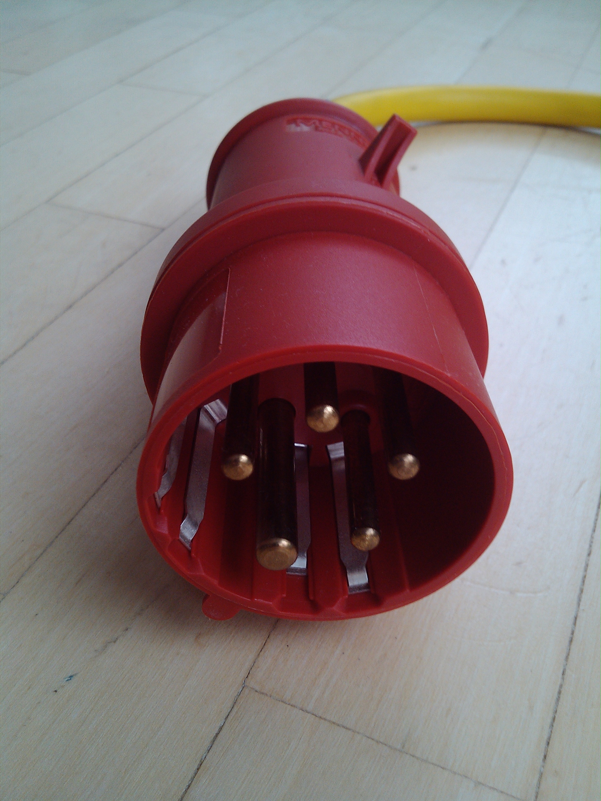
Only drawback: it uses a funky version of the standard red three-phase European plug with additional connection points. Yet another cable to grace our ever-growing collection of cables and plugs!
Just 2 minutes after me finishing packing all cables and getting ready to drive towards Oliver, he arrives and we start our adventure for real!
Oliver is in video production and mentioned during our preparations that he would be adding some video va-va-voom to our trip. He brought quite some gear with him – I’m curious to see what he’s going to come up with!
As always when traveling with TW560, the team takes a picture to mark the occasion – Oliver and I make a good team!

Austrian motorways require a toll sticker – a formality…for all 🙂

My plan for today was to charge about one km before entering the Arlberg Tunnel and then drive to Sölden with the new charge.
Everybody has a plan until they get punched in the face.
-Mike Tyson.
The Arlberg Tunnel is closed until November 14, 2015 which means we will have to cross over the pass! Weather is good and we made great progress on the motorway, so the only thing we need is a charging station somewhere along the road up the Arlberg.
Thanks to VLOTTE, there was (!) and we could lean back and enjoy the drive.

With 0% left, we arrive at the charging station, about 4 km from the Arlberg pass. 2 minutes later, TW560 is charging at 32A and we spend the charge walking and enjoying the alpine scenery.


Just over an hour later, TW560 is ready for the next part of the trip – the drive to Sölden.

We more or less roll down the Arlberg and down the valley. On the motorway we reach speeds up to 115km/h – effortlessly, silently @ 43W 😉
70 sunny km later, we leave the motorway to enter the Ötztal, made world-famous by Ötzi a well-preserved Tyrolean Iceman from about 3300BC, found 1991.

Just a few km into the Ötztal, we stop to marvel at the beauty of this place. Slowly, my theory of “it’s nice anywhere” seems to just be a self-fulfilling prophecy coming together over and over in the form of entries in this blog 😉

We munch heavily into our remaining charge. Our drive from Arlberg to the start of the valley was very economic at 40Wh/km @ avg. 76km/h – a 1250m climb to Sölden does require some energy!

With yet again just double digit Wh left in our battery, we make it to the Hotel we’ve chosen for the night. Our plan is to charge the battery to about half full whilst checking-in and settling down before attempting to reach the highest point of Europe.

30 minutes later – we’re ready to go. I forgot to give the motor a chance to cool by charging with off-board chargers only – let’s see if this will not prove to be a problem when climbing 1500m in only 12 km!
The road starts in the village of Sölden and is the main traffic axis to bring skiers to the glacier-based ski-resorts of Rettenbachgletscher and Tiefenbachgletscher.

Oliver starts to connect yet more video capturing devices to TW560.

Just a few kms into the climb, we get to a toll booth and get to pay €9.50. Granted, the road surface is perfect and I suspect that keeping the road snow free in winter will be a major challenge that doesn’t come cheap!

Included in the price is a sticker, proving to the world that the vehicle has been to the highest point in Europe.

Back to the climb. Temperatures are soaring and I’m glad Oliver has me stop the TWIKE from time to time in order to prepare some action shots for the video he’ll be producing. (He promised me to create a small teaser this very evening)

We are way past the tree limit and enter a raw alpine environment usually covered in snow. There is little vegetation and just some goats able to sustain themselves from the little green patches here and there.

Hair-pin bend after hair-pin bend leads us further towards the end of a valley which we know will itself end in a tunnel taking us up to the highest point in Europe and our goal for today.

Ah. Something is missing in this picture!

This is one huge ski resort! – two sides of a mountain plus multiple other lifts. This translates to a few very large parking lots hugging the mountain sides and a rather ungainly sight of lots of concrete.
Most slopes are open for skiing. The snow looks rather thin and battered – certainly not much fun to ski right now. (Skiing is my favourite sport – more on that later this year: TWIKE & skis work very well! 🙂 )

And just a few minutes later: We made it! Our GPS shows 2822m – according to the sign at the tunnel entrance we’re at 2809m altitude! A few hundred metres later (& lower) the road ends and we can take the typical picture everyone takes here (& I had posted yesterday as a stock picture)

Although everything is closed, air temperature is at 2°C and first snow flakes start falling within minutes of us arriving, we’re really happy to have made it!

One of the interesting parts of electric motoring is recuperation i.e. capturing surplus kinetic energy and charging the battery when driving downhill.
Normally one does not get to drive downhill for 15 minutes like here. Oliver and I am very curious how much energy we’ll be getting back on our way back down to Sölden.
We spent 3.5kWh to get up to the highest point – we start our descent with our counter at 9257Wh.

How did we do?

9257-8002=1.268kWh charged whilst driving 12 km! Mhhh, this feels really good!
Not having eaten anything since quite a while saw us parking the TWIKE at the hotel and heading to a restaurant immediately.
We found one serving local dishes and were immediately sold 🙂

We had some Gröstl and some large beers – soul food for travelers 🙂
Back at the Hotel – well fed – Oliver starts “throwing something together” as he puts it – and I settle into blog-entry-writing mode.
After just a few klicks he uploads the “TW560 driving to the highest point in Europe trailer” to his Youtube account and forwards me the link:
I do look very determined! *grin*
We’re both looking forward to our trip tomorrow. High passes, Italy, sourcing high-throughput plugs on a Sunday… you get the idea!
You guys are incredible. Wishing you safe trip and plenty of fun! Thanks for blogging, really enjoy reading that stuff!
Hi there, Stefan,
Always love hearing from you & thanks for your comment! You’re one of my most faithful readers @ 4+ years!
The trip yestderday was very nice – we’re both looking forward to tomorrow.
How about you joining me on one of these trips someday?
Hi Andrew,
Firstly, thank you for your response to my previous message on 15/09/15 and for adding a link to WeatherVelo. I’m sure you already know about http://www.friends-of-sam.com
Your blog about going up the Ötztal Glacier Road is fascinating. Thanks again for writing and illustrating so engagingly! Oliver’s video is wonderful. A question please: what is the system that you’re using for GPS and altitude etc.? Is it a smartphone app?
Looking at 37s in the video, there’s a lot of interesting info shown on the screen. I’m particularly curious to know what the green dots are on the compass (top half of screen).
All the best,
Simon.
Hi Simon,
Sam’s are a very interesting vehicle concept – I had the chance to drive a Cree Sam in 2011 for a week and really liked it…above all the unique vehicle dynamics when cornering. There are about 7 Sam’s close to where I live – this is why TW560 has already had interesting parking buddies. 🙂
The display you saw is an application called “GPS Status”. I like the details it shows -> see this screenshot for details. The green/gray/yellow lines show the channel status. The dots above show a virtual sky where all satellites are plotted with their current position.
/Andrew